


To some, it may feel like an eternity since the Luas Cross City works began, but the good news is Dublin's streets are almost rid of the diversions, road blocks and railings.
Construction on the new line began in June 2013, and it is scheduled to be in operation by the end of 2017. It's expected that trial runs will begin before this summer, with trams taking passengers in December.
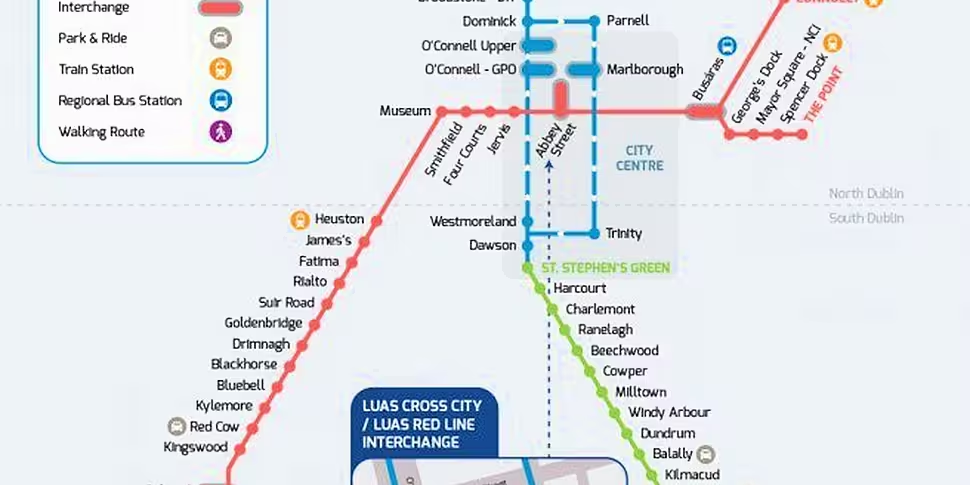
In anticipation of the finished line, Luas has created an integrated Luas Network map showing how the existing Luas Red Line and the Luas Green Line will operate in the city centre.
The new line will run from Stephen’s Green to Broombridge, with an interchange at Abbey Street where passengers can switch between the Red and Green lines.
The new O’Connell (GPO) stop is for passengers travelling north towards Broombridge, while those wanting to head to Stephen's Green or beyond will switch at the new Marlborough stop .

The connected lines are expected to carry an extra 10 million passengers every year along thirteen new stops from the city centre to Cabra. Most of the new stops will be in the city centre in areas like Dawson Street, Malborough Street and O'Connell Street.
The designers of the cross city line says it will take 21 mins to travel from St Stephens Green to Cabra.


